Chapter 15 Maps 78
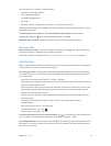
Get public transit directions. Tap Directions, then tap . Enter the starting and ending locations,
then tap Route. Or choose a location or a route from the list, if available. Download and open the
routing apps for the transit services you want to use.
Find out about trac conditions. Tap , then tap Show Trac. Orange dots show slowdowns,
and red dots show stop-and-go trac. To see an incident report, tap a marker.
Report a problem. Tap , then tap Report a Problem.
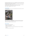
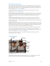
3D and Flyover
On iPad 3rd generation or later, you can see three-dimensional views and even y over many of
the world’s major cities.
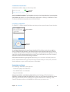
Use 3D or Flyover. Zoom in until or becomes active, then tap the button. Or, drag two
ngers up. To switch between 3D and Flyover, tap the lower-right corner and change views.
Adjust the camera angle. Drag two ngers up or down.
Maps settings
Go to Settings > Map. Settings include:
•
Navigation voice volume (iPad Wi-Fi + Cellular)
•
Distances in mile or kilometers
•
Map labels always appear in the language specied in Settings > General > International >
Language
•
Preferred directions by driving or walking


