


210 Brocade ICX 6650 Administration Guide
53-1002600-01
LLDP-MED configuration
8
altitude floors <number> is the vertical elevation of a building above the ground, where 0
represents the floor level associated with the ground level at the main entrance and larger values
represent floors that are above (higher in altitude) floors with lower values. For example, 2 for the
2nd floor. Sub-floors can be represented by non-integer values. For example, a mezzanine
between floor 1 and floor 2 could be represented as 1.1. Similarly, the mezzanines between floor 4
and floor 5 could be represented as 4.1 and 4.2 respectively. Floors located below ground level
could be represented by negative values.
resolution <bits> specifies the precision of the value given for altitude. A smaller value increases
the area within which the device is located. For floors resolution, enter the value 0 if the floor is
unknown, or 30 if a valid floor is being specified.
altitude meters <number> is the vertical elevation in number of meters, as opposed to floors.
resolution <bits> specifies the precision of the value given for altitude. A smaller value increases
the area within which the device is located. For meters resolution, enter a value from 0 to 30.
<Datum> is the map used as the basis for calculating the location. Specify one of the following:
• wgs84 – (geographical 3D) – World Geodesic System 1984, CRS Code 4327, Prime Meridian
Name: Greenwich
• nad83-navd88 – North American Datum 1983, CRS Code 4269, Prime Meridian Name:
Greenwich; The associated vertical datum is the North American Vertical Datum of 1988
(NAVD88). Use this datum when referencing locations on land. If land is near tidal water, use
nad83-mllw (below).
• nad83-mllw – North American Datum 1983, CRS Code 4269, Prime Meridian Name:
Greenwich; The associated vertical datum is mean lower low water (MLLW). Use this datum
when referencing locations on water, sea, or ocean.
Example coordinate-based location configuration
The following shows an example coordinate-based location configuration for the Sears Tower, at
the following location.
103rd Floor
233 South Wacker Drive
Chicago, IL 60606
The above configuration shows the following:
• Latitude is 41.87884 degrees north (or 41.87884 degrees).
• Longitude is 87.63602 degrees west (or 87.63602 degrees).
• The latitude and longitude resolution of 18 describes a geo-location area that is latitude
41.8769531 to latitude 41.8789062 and extends from -87.6367188 to -87.6347657 degrees
longitude. This is an area of approximately 373412 square feet (713.3 ft. x 523.5 ft.).
• The location is inside a structure, on the 103rd floor.
• The WGS 84 map was used as the basis for calculating the location.
Example coordinate-based location advertisement
The coordinate-based location advertisement will appear similar to the following on the remote
device, and in the CLI display output on the Brocade device (show lldp local-info).
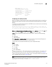
Brocade(config)#lldp med location-id coordinate-based latitude 41.87884
resolution 18 longitude 87.63602 resolution 18 altitude floors 103 resolution 30
wgs84