


Internet 87
NOTE: Touch More Layers to find more layers that you can apply
to the map. For information about the other layers, visit
maps.google.com.
NOTE: To remove all of the layers other than the map layer, touch
Clear Map.
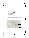
To view a map in street view
You can switch to street view for the location that you found on the
map. The street view is composed of imagery captured from the
streets.
1 Locate a place of interest on the map. For more information, see
"To find a location on the map" on page 84 and "To move around
a map" on page 86.
2 On the map, touch the name or address of the place.
3 On the location details screen, touch .
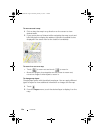
4 To view the 360-degree panorama of the area around the place,
turn the view on the screen with your finger.
5 To move the view along the street, touch the arrows displayed on
the screen, or touch the Menu button
Step forward or Step
backward.
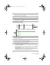
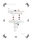
Map layer
The map layer displays streets, highways, buildings, main establishments,
mass transit stations, parks, rivers, lakes, mountains, boundaries, and so on.
Traffic layer
The traffic layer displays colored lines along the roads where real-time traffic
data can be collected. Green lines indicate good traffic speeds, yellow lines
indicate slower speeds, and brown lines indicate congested traffic.
indicates where construction work is taking place; indicates where the
road is blocked.
Satellite layer
The satellite layer displays the map in non-real-time satellite view.
Terrain layer
The terrain layer combines street maps with visual information about terrains.
Transit Lines layer
The transit lines layer displays mass-transit routes around the area.
LG7_bk0.book Page 87 Thursday, January 27, 2011 2:16 PM