


CONNECTIONS
2
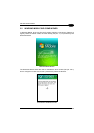
CAUTION
Before using the Datalogic Jet™ GPS, the user should become familiar
with the laws and regulations relating to satellite positioning in effect in
the country in which he is driving.
The distances indicated by the Datalogic Jet™ GPS can differ slightly
from those indicated on the road signs. In the event of a discrepancy,
the user must always follow the directions displayed on the road signs.
Data (maps, routes, fixed speed cameras, traffic information, points of
interest, etc.) are provided for information purposes, and are subject to
modification at any time.
We recommend to use these data taking into consideration the real
context of travelling: the general condition of the vehicle, its
equipment, the speed, the road surface, weather conditions, etc.
The user is expected to check road signs when using satellite
positioning, in particular for one-way streets and speed-limit signs. The
user must also follow the Highway Code and road safety rules
applicable in the country in which he is driving.
Non-compliance with these warnings could lead to accidents or
damage. Datalogic Mobile and/or suppliers accept no responsibility
for any use of products likely to provoke accidents, cause damage or
infringe on any laws or for any other consequences, whether direct or
indirect.
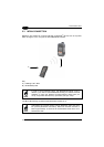
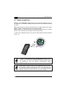
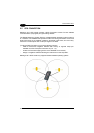
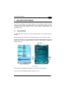
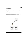
2.6 CRADLE CONNECTIONS
The Datalogic Jet™ can also communicate via RS232, USB and Ethernet, using
various cradle models.
For further details, refer to the specific cradle model User’s Manual.
21