


49
Apps
4. Tap Clear map to clear the map of all layers.
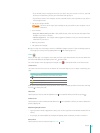
Trac Layer
Google Maps will either show current color-coded traffic conditions on highways and roads where
data is available.
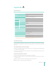
Color Description (highways) (Roads smaller than highways)
Green More than 50 miles per hour or 80 kilometers per hour The trac conditions are good
Yellow 25 - 50 miles per hour or 40 - 80 kilometers per hour The trac conditions are fair
Red Less than 25 miles per hour or 40 kilometers per hour The trac conditions are poor
Red/Black Very slow, stop-and-go trac The trac conditions are poor
Gray No data currently available
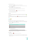
Transit Layer
Google Maps allows you to view available transit information overlaid on the map.
Types of transit - While the transit layer is active, you can view all transit types or limit what is shown
to Subway, Bus, Train, or Tram only. This lter is located in the upper right corner of the map.
Transit lines - By default, all transit lines are shown for a particular area. Zoom in to see the stops for
a certain line. Tap on a stop or station (indicated by a blue square) to highlight that line.
Station pages - Tapping on a stop or station (indicated by a blue square) will also bring up the
station page. This page provides information on which lines stop at that station and when the next
transportation will arrive. You can also get directions to that station, see Street view, or view nearby
stations.
Indoor Maps
Indoor Maps is built into Google Maps, which means you can use many of the same great Maps
features to explore your indoor space:
View and navigate floor plans of several commercial locations such as airports, department stores,
malls, and more within Google Maps.
Here are a couple ways you can use indoor maps:
Easily meet up with friends with Latitude while you’re out shopping.
Search for the nearest bathroom, coee shop, or airport gate.
NOTE
Indoor Maps is only available in selected locations.
View Indoor Maps
Indoor Maps works just like regular Maps. Search and see friends on Latitude the same way you would
with any location in Google Maps.
1. Find an available Indoor Maps location.
2. Zoom into the map until you start to see an indoor oor plan of the building.
3. Use the level switcher to move from the ground oor to other available oors in the building.
Search Indoor Maps
Search results for Indoor Maps won’t show unless you’re fully zoomed into a building where an indoor
map is available. Searching works just like it does in the rest of Google Maps.
Find Friends Indoors
If you use Latitude to share your location with friends, you can use the same Latitude features for
indoor locations. Latitude makes it easy to nd friends while you’re out shopping, dining or traveling.