


10 E-Series Installation Manual
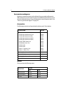
Media storage cards
Navionics Chart cards
To use your E-Series Display as a navigation aid, charts with detailed information for
the area you wish to navigate are required. The charts are available on Navionics
®
Chart cards.
A chart card provides an appropriate level of detail and scale for a given geographic
area.
To obtain suitable Navionics Chart Cards, contact your local dealer or visit the
Navionics web sites: www.navionics.com or www.navionics.it.
Alternatively, in North America call Navionics toll-free on 1-800-848-5896.
Outside of North America, contact your local dealer or call Navionics SpA on tel:
(+39) 0584 961696 or fax: (+39) 0584 961309.
CompactFlash cards
It is possible to archive or transfer information to and from your E-Series display and
other compatible instruments using CompactFlash cards. To achieve the best results it
is recommended that SAN DISK
®
CompactFlash cards are used.
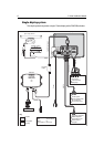
2.3 Functionality
For full functionality of the displays the following position and heading data is
required:
• Orientation - requires heading data derived from a suitable compass, for the
radar to operate in North Up or Course Up mode and the chart to operate in Course
Up and Head Up modes.
• Man Overboard (MOB) - requires heading and speed data. Alternatively, use
speed over ground (SOG) and course over ground (COG) derived from the same
source as position data (GPS).
• Mini Automatic Radar Plotting Aid (MARPA) and radar/chart over-
lay functions - requires accurate heading data. MARPA functionality is provided
if SOG and COG are also available. Increased accuracy will be obtained by using
fast heading data from a suitable compass, Smart heading sensor or compatible
Raymarine autopilot.
• Chart display - requires position data (GPS).