


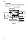

1. OPERATION
1-6
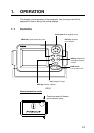
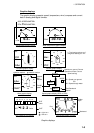
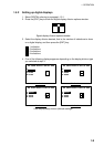
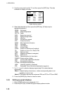
The highway display
The highway display provides a graphic presentation of ship’s progress towards
a destination, together with range and bearing to the destination, and ship’s
course and speed. To choose this display, select HIGHWAY from the USER
DISPLAY SETUP menu, referring to the procedure on page 1-8.
9.0
n
m
RNG
11°
SOG
n
m
N
Bearing from own ship to
destination waypoint*
Speed over
ground
0.3
XTE
0.05
BRG
COG
11°
k
t
12.5
Course over
ground*
0001
∆ C (Delta Course)
The own ship marker displays
course as follows:
When no waypoint is set;
The mode is North-up and
the own ship marker shows
ship's course.
When a waypoint is set;
The own ship marker shows
ship's course towards destination.
Destination waypoint name
Digital XTE indication
[+]
0.5 0.5
Range from own
ship to destination
waypoint
Analog XTE (Cross-track error) scale
Arrow shifts with ship's XTE. When the
arrow is aligned with intended course line
own ship is on course. The arrow flashes
if ship's XTE is greater than the XTE scale
range. "N" (North) is displayed instead of
the arrow when no destination is set.
Destination waypoint
"[+]" advances forward as own ship
nears destination.
I I I I I I I
Direction to steer (flashing)
Appears on left or right side
depending on direction to steer;
: Steer right, : Steer left.
Intended course line
* = True bearing shown as "
°
";
magnetic bearing as "
°
M".
Highway display