


E67
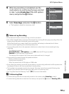
GPS Options Menu
Reference Section
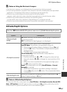
B Notes on Using the Electronic Compass
• The electronic compass is not displayed when the camera lens is facing upwards.
• Do not use the electronic compass in this camera for mountain climbing and other specialized
applications. The displayed information is intended as a general guide only.
• Direction may not be measured correctly near the following objects:
magnets, metals, electrical motors, electrical home appliances or electrical power cables.
• Direction may not be measured correctly in the following places:
in automobiles, trains, ships, airplanes, inside buildings or in underground malls
• Direction may not be measured correctly if the position information is not recorded.
Altitude/Depth Options
B Note on Altitude/Depth Options
To correct the altitude or water depth using Use GPS data of Alt./depth correction, Record GPS
data in GPS options of the GPS options menu must be set to On and also, positioning must be
enabled based on signals received from four or more satellites (A84).
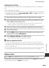
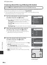
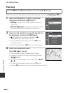
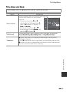
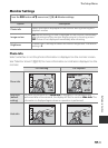
Press the d button M z (GPS options) menu icon (A8) M Altitude/depth options
Option Description
Altimeter/depth
gauge
On (default setting): The altimeter or depth gauge is displayed on
the shooting screen.
Off: The altimeter or depth gauge is not displayed.
Alt./depth correction
The altitude or water depth value is compensated.
Use GPS data: The altitude is compensated using GPS.
• When the confirmation dialog is displayed, choose Yes and
press the k button. The altitude is compensated using the
displayed value.
• The data is not compensated underwater.
Correct manually: Enter the altitude or water depth to
compensate the data.
• Use the multi selector H or I to change the value and use
the multi selector J or K to change the input position of the
digits.
• When the cursor is positioned on the rightmost digit, press
the k button to set this value.
Reset: The compensation set using Use GPS data or Correct
manually is canceled.
• When the compensation cancellation dialog is displayed,
choose Yes and press the k button. The compensated value
is cancelled.
Altitude/depth units
Set the unit of distance for displaying altitude or water depth to “
m
(meters)” (default setting) or “
ft
(feet).”