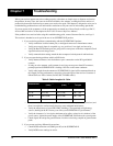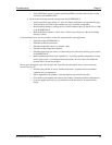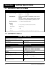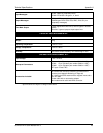
38 SUPERSTAR II User Manual Rev 3
Chapter 6 Positioning Modes of Operation
The following single frequency modes of operation are described further in this chapter:
• Single Point or Autonomous
• Satellite-Based Augmentation System (SBAS)
See Appendix G, GPS Overview on Page 67 for an overview of GPS positioning.
6.1 Single-Point or Autonomous
The NovAtel SUPERSTAR II receiver is capable of absolute single-point positioning accuracies of < 5 meters
CEP (GDOP < 2; no multipath).
The general level of accuracy available from single-point operation may be suitable for many types of
applications that do not require position accuracies of better than 5 m CEP. However, increasingly more and
more applications desire and require a much higher degree of accuracy and position confidence than is possible
with single-point pseudorange positioning. This is where differential GPS (DGPS) plays a dominant role in
higher accuracy real-time positioning systems, see also Section G.3, GPS Positioning on Page 69.
By averaging many GPS measurement epochs over several hours, it is possible to achieve a more accurate
absolute position.
The next section deals with the type of GPS system errors that can affect accuracy in single-point operation.
6.1.1 GPS System Errors
In general, GPS SPS C/A code single-point pseudorange positioning systems are capable of absolute position
accuracies of about 5 meters or less. This level of accuracy is really only an estimation, and may vary widely
depending on numerous GPS system biases, environmental conditions, as well as the GPS receiver design and
engineering quality.
There are numerous factors which influence the single-point position accuracies of any GPS C/A code
receiving system. As the following list will show, a receiver’s performance can vary widely when under the
influences of these combined system and environmental biases.
• Ionospheric Group Delays – The earth’s ionospheric layers cause varying degrees of GPS signal
propagation delay. Ionization levels tend to be highest during daylight hours causing propagation
delay errors of up to 30 meters, whereas night time levels are much lower and may be as low as 6
meters.
• Tropospheric Refraction Delays – The earth’s tropospheric layer causes GPS signal propagation
delays. The amount of delay is at the minimum (about three metres) for satellite signals arriving from
90 degrees above the horizon (overhead), and progressively increases as the angle above the horizon
is reduced to zero where delay errors may be as much as 50 metres at the horizon.
• Ephemeris Errors – Some degree of error always exists between the broadcast ephemeris’ predicted
satellite position and the actual orbit position of the satellites. These errors will directly affect the
accuracy of the range measurement.
• Satellite Clock Errors – Some degree of error also exists between the actual satellite clock time and
the clock time predicted by the broadcast data. This broadcast time error will cause some bias to the
pseudorange measurements.
• Receiver Clock Errors – Receiver clock error is the time difference between GPS receiver time and
true GPS time. All GPS receivers have differing clock offsets from GPS time that vary from receiver
to receiver by an unknown amount depending on the oscillator type and quality (TCXO verses


