


PinPoint EDGE/GPRS - User Guide, version 2.32 136
APPENDIX F GPS Message Format Streams
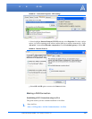
This appendix shows the GPS message streams provided by the PinPoint.
NMEA Message Description
The standard GPS data stream provided by the PinPoint in raw serial (ASCII) format is comprised
of (3) GPS NMEA receiver messages (“sentences”): GGA, RMC and VTG. All NMEA messages
start with a dollar sign ($) followed by a message type identifier. After the identifier, the fields of
the messages are comma deliminated.
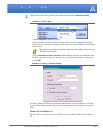
Example taken from PinPoint output:
$GPGGA,173221.428,3505.1435,N,08037.5669,W,1,04,2.2,242.9,M,46.9,M,,0000*1E
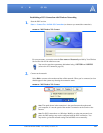
TABLE 1. GGA - Global Positioning System Fix Data
Description Field Contents
Global Positioning System (GPS) GP
Global Positioning System Fix Data GGA
UTC (Fix taken at 17:32:21 UTC) 173221.428
Latitude 3505.1435
North or South N
Longitude 08037.5669
East or West W
Fix Quality
(0=invalid, 1=GPS fix, 2=DGPS fix)
1
Number of satellites being tracked 04
Horizontal dilution of precision (metres) 2.2
Antenna altitude above/below mean-sea-level
(geoid)
242.9
Units of antenna altitude, meters M
Geoidal separation, the difference between the
WGS-84 earth ellipsoid and mean-sea-level
(geoid)
"-" means mean-sea-level below ellipsoid
46.9