


PinPoint EDGE/GPRS - User Guide, version 2.32 34
CHAPTER 7 Global Positioning System (GPS)
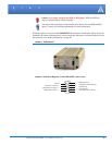
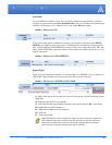
The PinPoint is equipped with a GPS receiver to ascertain its position to track the movements of a
vehicle or other devices which move. The PinPoint relays the information of its location as well as
other data for use with tracking applications.
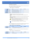
Tracking Applications used with AirLink modems:
• Air-Trak
• Track Your Truck
• Track Star
• DeLorme Street Atlas USA
• Microsoft Streets and Trips
• CompassCom
• Zoll Data
• and many more...
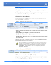
GPS Overview
The Global Positioning System (GPS) is a satellite navigation system used for determining a loca-
tion and providing a highly accurate time reference almost anywhere on Earth. The US military
refers to GPS as Navigation Signal Timing and Ranging Global Positioning System (NAVSTAR
GPS).
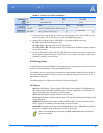
GPS consists of a “constellation” of at least 24 satellites in 6 orbital planes. Each satellite circles
the Earth twice every day at an altitude of 20,200 kilometres (12,600 miles). Each satellite is
equipped with an atomic clock and constantly broadcasts the time, according to its own clock,
along with administrative information including the orbital elements of its motion, as determined
by ground-based observatories.
A GPS receiver, such as the PinPoint, requires signals from four or more satellites in order to deter-
mine its own latitude, longitude, and elevation. Using time synced to the satellite system, the
receiver computes the distance to each satellite from the difference between local time and the time
the satellite signals were sent (this distance is called psuedoorange). The locations of the satellites
are decoded from their radio signals and a database internal to the receiver. This process yields the
location of the receiver. Getting positioning information from fewer than four satellites, using
imprecise time, using satellites too closely positioned together, or using satellites too close to the
Earth’s curve will yield inaccurate data.