


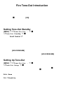

122
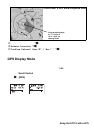
Location-Based (GPS) Scanning
T he BCT15 uses data, supplied by an attached GPS unit, that lets the radio
automatically unlock and lockout sites based on the geogr aphical information you
provide.
• Lati tude (the center of the range or site)
• Longitude (center of the range or site)
• Range (the radius of a circle around the latitude and longitude coordinates
selected fr om u p to 50 miles form tha t ce n ter.
You set the longitude and lati tude to appr oximate the center of a geogr aphi c entity
su ch as your local city. Then set the ran ge to en circle th at cen ter po in t. B y doing so
the scanner a uto mat ically locks out reception of an area outside t hat circle.
All geopoli tical areas are rarely perfect cir cles. You can accommodate these
va riat io ns by ent ering mult ip le site s f or th e syst em, even t houg h the syste m
actually has only one site, and use different location settings for each of those
additional sites.
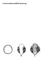
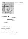
F igure A shows, schematically, an ideal reception situation. The area almost
m atches the site area. Bu t Figure B is mo re like the real wo rld. How d o yo u
effecti ve ly matc h the na rr o w geogr ap hi ca l ar ea to the ci rc u l ar si te tr ansm iss ion?
Fi gure C shows the ans wer. You create mul ti pl e si tes for the sc anner . You program
the longitude and latitude, and the range, of each of the three sites to more closely
ma tc h the ge ograph ic ar ea .
Figure A Figure B Figure C