


2-20
Cisco ONS 15454 Installation and Operations Guide
November 2001
Chapter 2 Software Installation
Working with the CTC Window
Note You can obtain the longitude and latitude for cities and Zip Codes from the U.S. Census Bureau U.S.
Gazetteer website (http://www.census.gov/cgi-bin/gazetteer).
Procedure: Change the Network View Background Image
Caution Before you begin this procedure, verify that the image file you want to use is located on your hard
drive and is in JPEG or GIF format. CTC may stop responding if you link to a file that is not JPEG
or GIF, or if you provide an incorrect path.
Step 1 In network view, choose Edit > Preferences. (You also right-click the network or domain map and select
Set Background Image.)
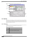
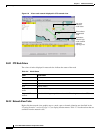
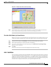
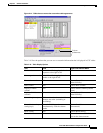
Step 2 On the General tab of the Preferences dialog box (Figure 2-10), deselect Use Default Map.
Figure 2-10 Changing the CTC background image
Step 3 Click Browse. Navigate to the graphic file you want to use as a background.
Step 4 Select the file. Click Open.
Step 5 (Optional) Enter the coordinates for the map image edges in the longitude and latitude fields on the
Preferences dialog box. CTC uses the map’s longitude and latitude to position the node icons based on
the node coordinates entered for each node on the Provisioning > General tabs. Coordinates only need
to be precise enough to place ONS node icons in approximate positions on the image. You can also drag
and drop nodes to position them on the network view map.
Step 6 Click Apply and then click OK.
Browse to
alternate images
55024