


AlliedWare Plus Version 2.2.4 Management Software Web Browser User’s Guide
319
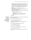
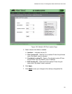
Altitude— Enter an altitude in meters or floors. For the altitude in
meters, the range is -2097151.0 to 2097151.0 meters. The
parameter accepts up to eight digits to the right of the decimal
point. For altitude in the number of floors, the range is -2097151.0
to 2097151.0. Use the Altitude Type field to specify meters or
floors.
Altitude Type— Choose between meters and floors.
Altitude Resolution— Enter altitude resolution as the number of
valid bits. The range is 0 to 30 bits.
Datum— Select the geodetic system (or datum) of the coordinates.
Choose one of the following:
WGS84: World Geodetic System 1984
NAD83_NAVD: North American vertical datum 1983
NAD83_MLLW: Mean lower low water datum 1983
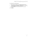
7. Click Apply.
Creating an
Emergency
Location
Identification
Number (ELIN)
Location
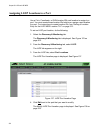
The ELIN TLV specifies the location of a network device by its Emergency
Location Identifier Number (ELIN).
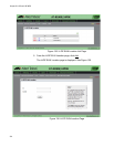
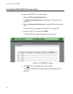
To create an LLDP ELIN location, do the following:
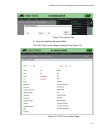
1. Select the Discovery & Monitoring tab.
The Discovery & Monitoring tab is displayed. See Figure 123 on
page 302.
2. From the Discovery & Monitoring tab, select LLDP.
The LLDP tab appears on the right.
3. From the LLDP tab, select Locations.
The Locations tab is displayed. See Figure 130 on page 313.
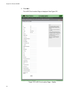
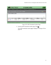
4. From the Location tab, select ELIN.
The LLDP ELIN Location List page is displayed. See Figure 135 on
page 320.