


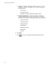
Chapter 25: LLDP and LLDP-MED
334
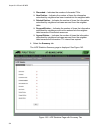
The following fields are displayed:
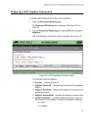
ID— Indicates the LLDP Coordinate Location ID.
Latitude— Indicates the latitude value in decimal degrees.
Latitude Resolution— Indicates the latitude resolution as the
number of valid bits.
Longitude— Indicates the longitude value in decimal degrees.
Longitude Resolution— Indicates the longitude resolution as the
number of valid bits.
Altitude— Indicates the altitude.
Altitude Resolution— Indicates the altitude resolution as the
number of valid bits.
Datum— Indicates the geodetic system (or datum) of the
coordinates. The datum codes are:
WGS84: World Geodetic System 1984
NAD83-MLLW: Mean lower low water datum 1983
NAD83-NAVD: North American vertical datum 1983
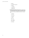
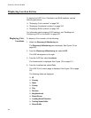
Displaying ELIN
Locations
To display an LLDP ELIN location, do the following:
1. Select the Discovery & Monitoring tab.
The Discovery & Monitoring tab is displayed. See Figure 123 on
page 302.
2. From the Discovery & Monitoring tab, select LLDP.
The LLDP tab appears on the right.
3. From the LLDP tab, select Locations.
The Locations tab is displayed. See Figure 130 on page 313.
4. From the Location tab, select ELIN.
The LLDP ELIN Location page is displayed. See Figure 136 on page
320.
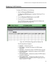
The following fields are displayed:
ID— Indicates an ID number for a LLDP-MED coordinate location
entry on the switch.
Elin ID— Indicates the ELIN of 10 to 25 digits.